Frank Lake is one of the best birding venues in the Calgary area.
The lake, situated about 50 km southeast of Calgary, is a shallow slough typical of the grasslands of southern Alberta. Directions are given from the southern edge of Calgary where Hwy 2 intersects with Hwy 22X (the Marquis of Lorne Trail).
To reach the lake, drive south on Highway 2 (Macleod or Deerfoot Trail south) until you reach Highway 23. At the junction with Hwy 23 (41.3 km), take the exit east towards Vulcan. At 47.3 km, the highway makes a 90° turn to the north. As you approach this corner slow down and watch for a sign and large gate on the right-hand side of the road. Following this gravel path will take you to an observation blind on the north edge of the lake.
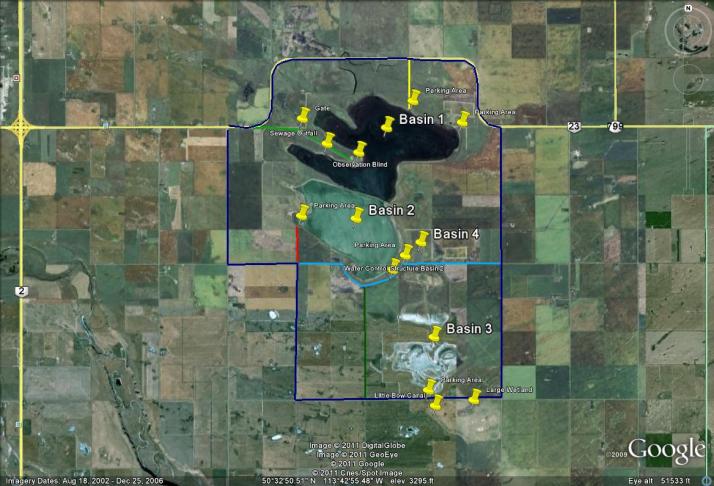
See the map below for other viewing areas around the lake, and be aware some of the areas may be flooded in a wet spring.
—————————————————
From Greg Wagner:
Several people have asked me to put together a map showing various areas of Frank Lake. The map below shows a variety of roads, parking areas and features around the lake.
The Dark Blue Line around the lake is a circuit that will take you around it using highway 23 and gravel roads. Good for travel outside the open water season, and it will take you around the lake to various basins and parking areas. Lots of wetlands around the lake which are always worth looking at.
Light Green Line – route into the west side of Basin 1, including the sewage outfall and observation blind.
Yellow line – trail into the northeast part of Basin 1. Should only be used in dry weather. Some prairie habitat at this spot.
Parking Area east part of Basin 1. Actually unsure if you can drive to this spot, but there is a large Frank Lake sign at the location.
Teal Line – is the trail around the south end of Basin 2. Fairly rough road which may be tough on small cars. Watch for the wet area south of Basin 4 when approaching from east. Do not drive on when wet, even if it is slightly wet. There is a stream crossing along the road at the Ducks Unlimited weir at the south end of the lake. The surface of this crossing is hardened and can be crossed even when water is present.
Red Line – trail into the northeast Bay of Basin 2.
Green Line – trail into the middle part of the trail around Basin 2. Use only during dry conditions. Not really recommended for travel.
Click on map for larger version
1 Comment
Wow ! wanted to visit here..